Saluting Marie Tharp, the Trailblazing Scientist Whose Maps Shook the World
Marie Tharp blew in to New York from the Midwest in 1948, looking for work. Twenty-nine years old and armed with degrees in geology and math, Tharp inquired at Columbia, where she was told to contact Maurice Ewing, director of the new Lamont Geological Observatory, now the Lamont-Doherty Earth Observatory (LDEO). Not known for his high regard for women scientists, Ewing wasn’t sure what to do with Tharp. Finally he said, “Can you draft?”
Tharp had sketched maps in grad school, and her father had made soil-survey maps for the government. Mapmaking was in her DNA. Ewing hired her, and she became the assistant to a grad student, Bruce Heezen ’57GSAS. Over the next decade, the three scientists collaborated and collided, jolting the field of geophysics and reshaping our understanding of the mechanics of the planet.
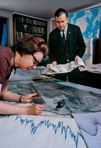
Heezen worked on research vessels in the North Atlantic, taking soundings of the sea floor with sonar. At the time, women weren’t welcomed on these ships, so Tharp stood over drafting tables in Lamont Hall and plotted the data, using tens of thousands of soundings made by Heezen and others to discern the subtle features of the ocean floor. She completed six west–east elevation profiles of the North Atlantic sea floor at different latitudes. All the profiles accounted for the Mid-Atlantic Ridge, a north–south undersea mountain range first detected by oceanographer Matthew Fontaine Maury in 1853.
Tharp then noticed something odd: while each profile had its own distinct topography, all six bore the same V-shaped indentation running down the middle of the mountain chain. Tharp thought it might be a rift valley — formed where magma had erupted, splitting the ridge in two and pushing it apart.
This was a potential bombshell. A rift valley would support the theory of continental drift, which held that all the continents were once a single land mass and have been separating ever since. The idea, advanced by German geophysicist Alfred Wegener in 1912, was widely scorned by scientists; Ewing was fiercely anti-drift. “If you brought it up, people looked at you funny,” says LDEO researcher Bill Ryan ’71GSAS, who had an office next to Tharp’s. “Marie Tharp was much more open to continental drift.” At the time, Heezen sided with Ewing, actually dismissing the rift valley as “girl talk.” But Tharp was undeterred.
Meanwhile, Heezen had taken on a project for Bell Laboratories, plotting the epicenters of marine earthquakes. He found that these epicenters were located not just along the Mid-Atlantic Ridge but within Tharp’s speculative valley. By 1953, Heezen was convinced that a continuous underwater mountain range wound around the planet like a baseball seam — and that a central valley ran through it. Heezen had come around to the idea of the rift valley.
For Ewing, any such claim was sacrilege. But in 1959, Jacques Cousteau, a rift-valley skeptic, crossed the Atlantic towing a submerged movie camera that, astonishingly, revealed the cliffs that framed Tharp’s valley. That same year, Tharp, Heezen, and Ewing published the first map of the North Atlantic sea floor: a bird’s-eye view of the terrain as it would look without water.
In its varied topography of mountains, ridges, and canyons, the map was revelatory: many had presumed the sea floor to generally be flat. But despite the map’s success, a long-simmering academic feud between Ewing and Heezen intensified in the 1960s, threatening future mapping projects. Ewing couldn’t fire Heezen, who was tenured, so he fired Tharp instead. But Heezen, funded by the Navy, continued his research while Tharp worked from home, supported by Heezen’s grant.
Tharp and Heezen produced other maps, culminating in their 1977 panorama of the entire ocean floor, painted by the artist Heinrich Berann. Heezen died that year at fifty-three.
Tharp died in 2006 at eighty-six. Her accomplishments run deep: her maps became classics, and her rift valley gave rise to the theory of plate tectonics, which holds that the earth’s crust and mantle are fractured into sections that fit together like puzzle pieces. She reconciled with Columbia after Ewing left in 1970 and later stated that she had no regrets. “I was lucky to have a job that was so interesting,” she once said. “Establishing the rift valley and the mid-ocean ridge that went all the way around the world for forty thousand miles — that was something important.”
The US Navy agrees. Earlier this year, Navy secretary Carlos Del Toro announced that the name of the survey ship Maury had been changed to Marie Tharp. History notes that Tharp didn’t board a research vessel until 1968. Now, finally, her ship has come in.